Showing posts with label Wisconsin River. Show all posts

Wednesday, August 28, 2013

Lower Wisconsin Riverway


Between Lodi and Prairie du Chien, in the Driftless Area of southwest Wisconsin, you'll happen upon Scenic Byway 60 winding along the curves of the Wisconsin River. To properly enjoy this scenic road trip, you'll have to put away your electronic devices, stop looking at your watch and turn off the GPS. Put on your favorite music, roll down the windows and let your hair blow in the breeze. Hopefully you're lucky enough to be the passenger on this drive so you can enjoy the views without having to concentrate on driving. But even drivers will appreciate the gentle curves gradually leading you up hills and back down into valleys as you keep the speedometer at a steady 55 miles per hour, only slowing as you pass through the quaint towns or to stop at local shops, restaurants and attractions.


To me, there is nothing better than taking a road trip with my dog and the weather cooperated perfectly. Charlie was pleased to have the sun roof open on this trip so she could drink in the smells of the river and fields as we cruised down the highway. She LOVES cows and I made sure to alert her when we were nearing another field so she could return their lazy gaze. Many farmers were baling sweet smelling hay in their freshly cut fields, churning out golden cubes in long rows.

Before you cross the bridge over the Wisconsin River to Prairie du Sac, take a quick detour down Hwy. 188 to the Wollersheim Winery. The historic buildings built by Europeans in the 1850's along with the vineyards situated on the slopes overlooking the Wisconsin River will inspire a relaxed frame of mind for the rest of your road trip. Stock up on some delicious wine while you're there to enjoy when you get home!


The farm fields occasionally give way to riverfront and the low water level reveals a multitude of sandbars full of campers, boaters and swimmers. People were out in droves taking advantage of these warm dog days of summer before school starts.


I'm always in awe of this driftless landscape:  On one side of the road, mounds of wooded hills rise out of the rolling meadows; on the other side lie marshy lowlands and sandbars of the Wisconsin River; and in between these beauties are waves of farm fields lined with ancient oaks keeping the different crops separated from each other.


We turned down Cassell Rd. to get a better view of the bluffs along this stretch of highway just before arriving in Spring Green. There was a grassy parking area with trails leading out into public lands where Charlie and I stretched our legs while taking pictures of the amazing bluffs.


I wanted to continue westward on this Scenic Byway, but we turned off Highway 60 at Spring Green and headed South on Hwy 23, toward family and our ultimate destination:  Platteville. Between Spring Green and Dodgeville, there are several stops you should consider making.

The first one that you'll encounter as you head south is Taliesin and the Frank Lloyd Wright Visitor Center. Just before you cross the bridge over the Wisconsin River to this architectural landmark, there's a park along the shoreline where you can take a break and go swimming if the weather is agreeable. On this particular weekend, the park was full of people enjoying the water and even dogs frolicking along the sandbar beaches and fetching frisbees in the sand. Although it was a busy weekend, it didn't feel crowded.

Next, you'll pass The House on the Rock. It's REALLY hard to describe this place and definitely something you'd have to see for yourself anyway. I actually took my 11-year-old niece there back in June and we spent almost the whole day exploring the collections. Make sure to pull over at the Scenic Overlook before you get to The House on the Rock; there's a view of the Infinity Room from across the valley that can be seen from the Overlook on both the northbound and southbound sides of the highway. When Charlie and I first arrived at this spot, I wasn't quite sure what we were supposed to see; after I took the photo below we turned to head back up the trail and I caught a glimpse of the Infinity Room and knew exactly what I was looking at! It was like finding a secret!

Self portrait of me and Charlie at the Scenic Overlook.

The Infinity Room is way off in the distance on the bluff.

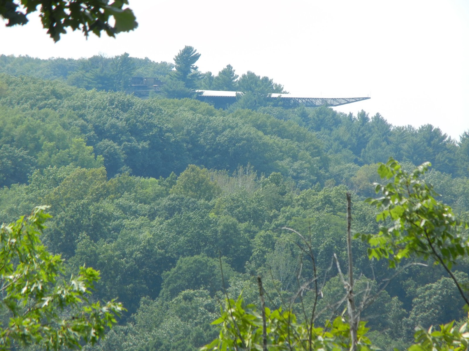
Zoomed in on the Infinity Room from the Scenic Overlook.

View of the Infinity Room from the Northbound Scenic Overlook (bridge connects both sides of the Overlook)

View of Highway 23 from bridge at Scenic Overlook.
After The House on the Rock, as you approach Dodgeville, you'll discover Governor Dodge State Park. I've previously reported on this beautiful (and dog friendly!) park, but you'll want to plan ample time to explore it because there is too much to see in one day.

This upcoming Labor Day Weekend is a perfect time for a scenic road trip. The countryside is brimming with sights to see, a new treasure to behold around every curve. Even if you just go for a drive with no destination and don't make any stops at all, your mind will be full of all the beautiful images of the scenery along the way, and that is priceless. Get out there and find a scenic drive this weekend... you might be surprised at what you find and you'll definitely come away with a deeper appreciation for your part of the world!


Sunday, May 12, 2013

Ice Age Trail - Grandfather Falls, Part 2

I took my own advice and headed into the woods this weekend. I sat on a rock, listened to the wind in the tree branches along with the roar of the nearby falls, and let nature center my spirit. The terrain was all new to me since the last time I was here there was 2 feet of snow covering everything. Rocks, tree roots and leaf debris, combined with dampness from the recent snow-melt and rains made traversing the narrow trail difficult in some areas.


We quickly covered the previously hiked section of trail and were excited to explore the next section above the dam at Grandfather Falls. Having studied the map and trail description from the Ice Age Trail Companion Guide, I was better equipped with the knowledge of where to go. After reaching the dam and crossing the parking lot, I had a little trouble figuring out where the trail was, and then I spotted a narrow stone staircase.


We walked through a brief wooded area and out into the open fields of the hydroelectric plant. This area is immersed in history - all the way back to the Ice Age - and I paused to absorb it all. The logging industry has been a huge part of this landscape dating back to the late 1800's and it's also the site of the Wisconsin Conservation Corps Camp McCord from the 1930's. I was most looking forward to seeing the wood-banded pipelines that carry water down hundreds of yards from a man-made reservoir upriver. The Ice Age Trail Companion Guide describes the "fascinating tubular fountain effect" made by hundreds of small leaks occurring at knotholes in the wood. Amazingly, wood was used for these pipelines because it doesn't corrode or rot under the constant water pressure. I was completely in awe; these tubes were MUCH larger than I had imagined! 


Next up were the 1.8-billion-year-old boulders at Grandfather Falls. If you sit on one of these rocks and think about how old it is, you really begin to appreciate the grandness around you. And also how "small" your lifetime is in comparison. It's a humbling experience.


The trail became quite challenging from this point on. Tree roots wove themselves around the rocks and at times, the rocks and boulders took over the trail so much that I needed to find the yellow rectangles on trees to make sure I was still on the trail.


The trail is beautiful and very remote. I felt like I was the only one out there, although I did pass fisherman along the shore a few times. It's difficult to hear much of anything except the falls roaring alongside the trail. We experienced just about every type of weather on this day and I was grateful to be wearing my winter coat and earmuffs. One minute there would be smurf-blue skies with fluffy white clouds, then with no warning the skies would turn steel-gray with 40 mile-per-hour wind gusts. There would be sunshine one minute, and then it would start snowing. All I can say is, welcome to Wisconsin! And be prepared for any weather conditions on the trail.


The landscape and rock formations are truly magical. I wanted to continue on, but Charlie was showing signs of crabbiness due to being overly tired, so we headed back. I'm looking forward to hiking this trail and the next segment, Turtle Rock Segment, without my dog along. While I know the exercise and fresh air are good for her, I don't get to fully relax when I'm worried about bear and wolves attacking her. Plus, she nearly scared the shit out of me when she got too close to the falls where I thought she might decide to go for a swim. Next time will be just for me.


Amazingly, on our way back, we ran into the same man that we met the first time we hiked the trail back in February. I told him I'd taken his advice and hiked up past the dam where he had told me the landscape was just beautiful. He had hoped that the spring wildflowers would be in bloom this weekend, as they have been on past Mother's Day weekends, but the late winter has delayed them. He recommended coming back in a couple of weeks to see the flowers. I'm pretty sure I will.

Sunday, May 5, 2013

Leash Hike: White Water Park

Barker-Stewart Island
Due to Charlie's blatant disregard for recall commands during yesterday's hike, I decided we would do a leash-walk along the Wisconsin River's River Edge Parkway today. We headed out toward downtown Wausau around 11:30am, merged onto the River Edge Parkway behind the Eye Clinic and went across the foot bridge to Barker-Stewart Island to do a lap around the trail and take a moment to watch the river as it lazily flowed past.

Remnants of original saw mill on island.
 
Train bridge on West side of island.
View of pedestrian bridge and downtown Wausau from East side of island.
After our lap around the island, we headed back to the River Edge Parkway and continued under the Scott St. bridge and behind the Marathon County Public Library where the dam for the White Water Park is located.
 
River Edge Parkway under Scott St. - hydro dam to the right.
Once we got behind the library, there's a short set of stairs that take you below the dam where kayakers enter the water at the top of the course.
 
Descending the stairs to the kayak launch platform below dam.
 
On the kayak launch platform looking upriver towards dam.
Charlie especially enjoys this spot to take a break, get a drink and explore along the shore. From here we crossed the street and headed down towards the White Water Park.


The River Edge Parkway continues along behind the seating area for the White Water Park and all the way down to Isle of Ferns Park. The picture below shows the beginning of the white water course as well as distant Rib Mountain and Granite Peak Ski Area in the background - with snow still on the slopes!


Ground seating along white water course.

Newly remodeled viewing area along course.
Here's a short video of the babbling water flowing over the boulders, followed by an impatient *BARK* from Charlie:


We got a little further down the trail when "nature called" and apparently the bathrooms are not open for the season yet, so we turned back and headed towards home, taking the Parkway through the undeveloped gap where it reconnects under Bridge Street. I had to steer Charlie around piles of broken glass, garbage and boards with nails sticking out of them... tempted to let her off-leash to run but too worried that she'd hurt herself on something.
 
Abandoned buildings along future expansion of parkway trail.
Once back on the trail, I started watching for river otters. I had spotted a pair of otters in this part of the river last year and am always on the lookout for them. Instead, I saw a dead deer in the water. What is it with finding death on all our walks?! Just a part of nature, I guess.
 
 
Charlie was really tired after two hours of walking. I was ready to go longer and just might go out again this evening by myself. It's been awhile since I've been on a solo walk (without dog) and think it might do me some good to have time to myself, untethered.


Monday, April 29, 2013

Snake!


Charlie came upon a snake sunning itself on the blacktop path tonight. This isn't the first snake she's seen, but she showed more curiosity toward it than she has in the past. Don't worry - they're completely harmless (garter snake).


The Wisconsin River is still high, making pretty swirls in the water as it flows past quickly. Charlie wasn't much in the mood for swimming tonight; just wanted to play with the grass and twigs submerged along the shore. And of course, the bouncy ball...


Such a sweetheart.

Thursday, April 25, 2013

Spring Thaw Flood: Picnic Island Park

Since the dam in downtown Wausau is wide open, we headed over to Picnic Island Park this evening to see how the spring thaw is affecting the Wisconsin River.


Charlie nearly gave me a heart attack when she decided to go swimming in the swirling, churning water! The current was strong enough to cause waves crashing on one side of the island! Luckily she's a strong swimmer and stayed close to shore, but I decided to move our game of fetch a little further inland so she wouldn't be tempted to try again.


Sunday, April 21, 2013

Wisconsin River Forest Unit

I'm going to dub this our "Spooky Carcass Hike." (WARNING: Graphic images below)

I was really looking forward to checking out this new hiking trail I researched late last week because it's only 8 miles North of Wausau's East side and follows along a portion of the Wisconsin River - water frontage is always a plus when you're hiking with a part-Lab dog!

We headed North on County Hwy W and almost missed the turn onto Pine Bluff Rd. The dirt/gravel drive into the parking area was pot-holed and half covered in ice and snow, but still passable without needing four-wheel-drive. As I pulled off the road to park, I noticed tufts of gray fur blowing around: an ominous sign. I let Charlie jump out as I loaded up the backpack with hiking essentials and when I turned around to see where she was, I found her sniffing a deer carcass!


Charlie was obviously worried about what she had found and continued being hesitant and skittish. Upon further investigation, there were several carcasses that had been dumped in and around the parking lot area, as well as unidentifiable animal body parts strewn across the entire parking area - probably scavenged by local wildlife. The smell of death was noticeable.


It appeared that the body parts were only around the parking area, so we continued down to the path. I don't know if it's because of what we saw at the head of the trail, but the entire hike was creeping me out. The caw of the crows made my spine tingle and every snap of a twig sent me twirling around to see who was there. I was spooked.


Charlie, however, had shaken off what we had found and was ready to go! She was very excited to be scouting new territory and took off ahead of me. I kept calling her to "COME!" because I didn't want her getting too far ahead; I wasn't sure what (or who) we were going to find. I think she was getting a bit frustrated with me though.


The terrain is very uneven and I was having a hard time watching my footing, holding onto my camera and keeping an eye on Charlie all at the same time. I tripped and slipped quite a few times, but luckily didn't fall. The constant hum of the traffic on nearby Hwy 51 was annoying and I kept hearing occasional gunshots - possibly from the nearby quarry?


The Wisconsin River is always high this time of year from the snow-melt, and this lowland area is obviously in part of the river's flood zone. Charlie got herself stuck in some ice-crusted mud and slopped around for a bit before being able to extract herself. She looked a little surprised at the feeling of being *stuck.*


She was having a wonderful time romping through the snow-and-leaf-strewn path, leaping over logs and sloshing around in the icy water; completely unaware of how spooked I still was. We came across some other "dead things" along the path... scattering of bird feathers, breastbone of something, smooshy black pile of something, and I couldn't shake the feeling of death all around me.


We arrived at the end of the trail sooner than I had thought we would. It wasn't the "actual" end of the trail, but the flooding had crept up enough to cover a wide swath of land and was impassable for now. We turned back and retraced our steps to the parking lot... which was a good thing because the snow was starting to come down pretty good by then.


We'll plan on checking out the other loop of trail when the snow melts a little more. That section of trail looked too snow-covered and there were no footprints to follow. Maybe the deer will be a bit more decomposed (or removed) by the time we return.

Happy Hiking!