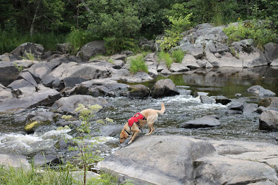
We took Highway 51 north from Wausau to Tomahawk and then west along Highway 86, with a quick stop at Spirit Falls to check out this geographic feature along the way. A short turn off Highway 86 onto Spirit River Ave. leads to a small grassy parking area where you'll find a wide trail back to the falls. Large rock outcroppings spill into the flowing water of Spirit River which create a pretty waterfall; it's a nice place to have a picnic or just sit and listen to the water flowing over the rocks. The multitude of rocks made it challenging for Charlie to swim since she kept stumbling over them in the water and when she slid down the rock-formed waterfall, there was nowhere for her to climb back up; she had to backtrack through the little tributary stream to the trail in order to meet back up with us at the car.
My Google directions were a little bit wrong so instead of continuing along County Road RR (which happens to be a Rustic Road!) to the entrance of Timm's Hill County Park, we turned onto Ring School Rd. If you have extra time, I highly recommend taking this "wrong turn" because it offers a stunning view of Timm's Hill from across Timms Lake - seriously, you'll feel like you're in a different country, like the Swiss Alps only smaller. Also, the road winds along rolling hills and past Ring School, which is so rustic and quaint you'll feel like you stepped back in time.
Unlike our recent outing to the observation tower at Roche-A-Cri State Park, this tower did not specify whether dogs were allowed or not, so I decided they are. And since no one else was currently using the tower, I figured I wasn't going to be bothering anyone by taking my dog up there. I felt completely sure that she would be safe since there was chicken-wire lining the handrails and top deck. But about halfway up, Charlie realized that we were pretty far from the ground and began to get a little nervous, so I took the lead and let her follow behind me.
 |
| We signed the register for Highpointers Summits of the States. |
The view from the top is pretty and you can see really far, but the treeline obscures the view of the lakes at the base of the hill, so all that can be seen of them is a tiny bit of shoreline and only if you look really hard. Honestly, after having been at the top of Rib Mountain and now here, I'd have to say that the view from Rib Mountain is much more scenic and feels as though you can see farther than on Timm's Hill... but that's just my opinion and you should probably check it out for yourself. I suppose on a crisp, autumn day when the sky is cobalt blue and the leaves are on fire with color, the view from up here might win over Rib Mountain.
After quickly descending the stairs and returning to solid ground, Charlie and I signed the register for the Highpointers Summits of the States; Charlie was happy to be back on the ground!
 |
| The red trail is the Ice Age Trail! |
Back at the parking lot, while studying the trail maps at the kiosk, I was surprised to see the Ice Age Trail listed in the legend; I hadn't realized the IAT was near Timm's Hill. Could I possibly have happened across another segment of the Ice Age Trail - by accident - for the second weekend in a row?!
Yep.
Unbelievable.
Without even trying, this trail seems to find me. But because we had spent so much time getting lost and taking the scenic route, we didn't have time to tackle this segment today; you can bet we'll be back though!


No comments:
Post a Comment